3rd typhoon in a row on a path to northern PHL; previous damage reaches at least P477M
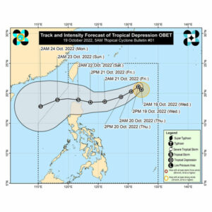
A TROPICAL depression that is seen to intensify into a tropical storm category by Friday night or Saturday morning is heading towards northern parts of the Philippines, on a path similar to those of the two most recent typhoons, according to the state weather agency.
The latest tropical depression named Obet, the 15th to hit the country this year, was spotted 920 kilometers east of extreme northern Luzon, based on PAGASA’s 5 p.m. weather bulletin on Wednesday.
Moderate to heavy rains could be expected over Babuyan Islands, Ilocos Norte, Apayao, and the northern portion of mainland Cagayan by Friday.
Light to moderate with at times heavy rains are also likely over Batanes, the northern portion of Ilocos Sur, Abra, Kalinga, and the rest of mainland Cagayan.
“Based on the latest forecast scenario, Tropical Cyclone Wind Signal may be hoisted for some areas in Northern Luzon tonight or tomorrow morning at the earliest,” PAGASA said.
Apart from the tropical depression, PAGASA said the prevailing northeasterly surface windflow will already bring strong to gale-force winds over these areas in the next 24 hours.
DAMAGEMeanwhile, the running assessment of damage to agriculture and public infrastructure due to the preceding typhoon, with international name Nesat and locally named Neneng, has reached more than P477.61 million as of Oct. 19.
Data from the National Disaster Risk Reduction and Management Council (NDRRMC) show damage and losses in crops and fisheries stood at P366.06 million.
Over 14,500 farmers and fisherfolk have been affected.
The Cagayan Valley Region suffered the biggest damage at almost P354.45 million. Other affected regions were the Cordillera ang Ilocos, according to NDRRMC.
No deaths were reported but at least two people were injured as Neneng brought heavy rains and strong winds.
There were 51 totally destroyed houses across the three regions and another 115 that were partially damaged.
NDRRMC has yet to update its impact report on the earlier tropical depression named Maymay, the 13th that entered the Philippines this year.
The Department of Agriculture (DA) on Wednesday issued a combined assessment on Maymay and Neneng, with damage pegged at P355.63 million.
Based on latest figures from the DA-Disaster Risk Reduction and Management, the onslaught of Maymay and Neneng affected 11,928 farmers and 15,850 hectares of agricultural land.
Lost production volume reached 25,297 metric tons (MT).
The affected commodities include rice, corn, and high-value crops. The figures are subject to validation, the DA said.
“The values of damage and losses for Maymay and Neneng have been combined as the two tropical cyclones occurred in a span of one week and affected the same agricultural areas in Cordillera Administrative Region, Ilocos Region and Cagayan Valley,” the DA said in its bulletin issued noon of Oct. 18.
Broken down, damage to rice reached P344.53 million. A total of 24,723 MT of produce were lost while 15,705 hectares of farmland were affected.
High-value crop losses amounted to P6.94 million. Some 191 MT of produce were lost while 18 hectares of agricultural land were affected.
Corn losses totaled P4.16 million. A total of 127 hectares of farm land were affected while 382 MT of produce were lost.
The department said while assessment is continuing, it is also rolling out agricultural commodities in the affected communities to help stabilize food prices. — Revin Mikhael D. Ochave and Marifi S. Jara