At least 4 die after Magnitude 7 quake hits northern Philippines
By Norman P. Aquino, Special Reports Editorand Kyle Aristophere T. Atienza, Reporter
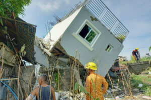
A MAGNITUDE 7 earthquake rocked the northwestern part of the main island of Luzon in the Philippines early Wednesday morning, according to the US Geological Survey (USGS), killing at least four, damaging buildings and halting train operations in the capital Manila where the tremors were also felt.
The quake struck about 13 kilometers (km) southeast of the town of Dolores in Abra province at a depth of 10 km, the US agency said on its website.
The Philippine Institute of Volcanology and Seismology (Phivolcs) reported more than 50 aftershocks ranging from magnitude 1.5 to 4.7 in Abra alone.
Two people from Benguet province and one each from Abra and Mountain Province died, Interior and Local Government Secretary Benjamin E. Abalos, Jr. told a news briefing.
At least two senior citizens were trapped in a landslide in Benguet, the province said on its Facebook page.
More than 130 people from 24 families in Tuba town in Benguet, which is a six-hour ride from Abra, were evacuated, the provincial government said, citing initial reports. More than 20 houses were damaged there.
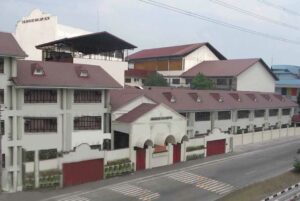
Several bell towers, churches and heritage houses in northern Philippines, as well as cars and other property were damaged by the quake, Senator Imee R. Marcos, who is from Ilocos Norte, said in a statement, citing unnamed sources.
Several main roads including Kennon, Paraiso, Pagudpud, Ilocos Norte and Apayao were also damaged, while much of the area did not have power after electrical transformers and transmission lines were hit, she added.
She urged police and the local disaster agency to remain vigilant because aftershocks could follow.” “If necessary, preventive evacuation of coastal villages and landslide-prone zones should be undertaken swiftly.”
State seismologists said there was no threat of tsunami because the fault line that triggered the earthquake was located on land.
“It won’t cause the seafloor to rise and lead to a life-threatening tsunami,” Renato U. Solidum, Jr., head of the state seismology agency, told a news briefing in mixed English and Filipino.
He cited reports of an “unusual wave” in the coasts of La Union and Ilocos provinces that he said was not a tsunami.
“A tsunami would be very high waves because of the uplift of the ocean floor due to an earthquake in the ocean,” he said. “What happened was there was shaking of the island and the coastal water was shaken, so there was minor seawater oscillation.”
“Some of the waters actually entered some of the rivers,” he added.
Since 1970, 11 other earthquakes of magnitude 6.5 or larger have occurred within 250 km of Wednesday’s earthquake, the USGS said.
The largest of these earthquakes was a magnitude 7.7 earthquake on July 16, 1990 in Baguio City in Benguet, where at least 1,600 people died and more than 3,000 were hurt, it added
The 1990 earthquake also caused landslides in the Baguio-Cabanatuan-Dagupan area.
The Wednesday quake was also felt in the capital region, where several buildings were evacuated and the rail system was halted during rush hour.
“Any earthquake at magnitude 7 is considered a major earthquake,” Mr. Solidum told a news briefing streamed live on Facebook.
More aftershocks were expected in the next two days, he said. “Strong intensities are still possible.”
“I urge everyone to stay alert and to prioritize safety in light of the possibilities of aftershocks that might be felt after that strong earthquake,” Abra Rep. Ching B. Bernos said in a statement. “We are monitoring the situation on the ground and gathering information on the extent of the damage to the province.”
NO STATE OF CALAMITYPresident Ferdinand R. Marcos, Jr. will only visit areas “where his presence is necessary,” Press Secretary Trixie Cruz-Angeles told a news briefing. “Let’s make an assessment first.”
A state of calamity declaration is “not necessary right now,” Mr. Marcos separately told a news briefing. “Depending on the information that comes back, that might happen. We have to wait for those reports.”
The quake has mainly affected 15 provinces in the regions of Ilocos, Cagayan Valley and the Cordillera Administrative Region, Mr. Abalos told the same briefing.
The President, who described the earthquake as “very strong,” said he would not immediately go to affected areas so the jobs of local authorities are not delayed.
“It has been my experience as governor that when the national officers go to the affected areas immediately, they just mess with the work of local officials,” he said.
“Let them do their work. Let us wait for them to tell us what is going to be — what the true situation is — and maybe I can schedule a trip perhaps tomorrow as soon as possible.” he added.
Mr. Marcos said his Social Welfare chief promptly visited affected areas after the quake. “We are awaiting his report.”
The Philippines lies in the so-called Pacific “Ring of Fire,” a belt of volcanoes around the Pacific Ocean where most of the world’s earthquakes strike.
At the briefing, Mr. Marcos backed a bill seeking to create a disaster resilience department.
“We need more capability than we have now,” he said. “We are now good with typhoons and we know a lot about earthquakes. But the dangers and effects of climate change are different, that’s why we need a specialty agency.” — with Alyssa Nicole O. Tan, Matthew Carl L. Montecillo and Marifi S. Jara