Google Maps reimagines navigation with AI

By Hazel Nicole Carreon
WITH OVER two billion active monthly users across the world, Google Maps continuously improves its platform with new updates to provide a fresh and comprehensive map to every user.
The product is now integrated with Gemini, Google’s artificial intelligence (AI) model. With this upgrade, drivers using Android and iOS devices will be able to get information on the places they can visit and things they can do in a specific area. Gemini will also be able to generate review summaries and quick answers to queries about these places.
Google Maps guarantees that the information provided will be updated and accurate, “grounded in trusted data on about 250 million places around the world and insights from the Maps community,” said Google Maps Vice-President and General Manager Miriam Daniel during a virtual roundtable discussion with members of local and international media.
These features debut in the United States recently, and the platform will also be rolling out an enhanced navigation system there that will clearly indicate the lanes, crosswalks, and road signs on the map — making driving along unfamiliar roads easier and stress-free.
For the rest of its markets including the Philippines, the navigation app launched the Flood Forecasting feature that can predict (also through AI) if a flood may be coming into an area, and gives notice to the user to help them evacuate as soon as possible.
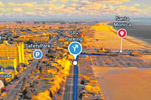
Furthermore, Google Maps now allows global users to plan their trip before heading out as it now provides a list of the best landmarks and dining options along their route. It also shows the nearest parking lots to the destination and walking directions from the car to the entrance.
Meanwhile, the Immersive View feature, which was launched in 2023, has expanded to 150 cities, including Kyoto, Brussels, and Frankfurt. It lets users see what a specific place looks like and even predicts the weather and traffic conditions on the area on the day and time of the planned visit.
Google Maps added new categories of places to Immersive View such as university campuses. This feature can now give suggestions on parking spots and warnings if there are complex turns ahead.
According to Geo, the Google team that develops its Maps, Earth, and Street View platforms, Immersive View was built using different innovations in AI, computer vision, and imagery technology. “We fused them together and helped create this photorealistic view of the real world going far beyond what you could get with a two-dimensional map,” Geo Vice-President and General Manager Chris Phillips stated.
Waze, another Google-owned navigation app, also launched a new feature that allows any user to report a range of incidents, such as traffic, potholes, construction, and more. Through the Conversational Reporting feature, drivers can simply tap the reporting button and speak naturally, then Waze will automatically add a real-time report to the map to make other users aware of the situation in the area.
The feature was rolled out in beta to Waze’s trusted testers across the world. Waze is also set to release the School Zones feature later this year, enabling users to receive an alert reminding them to drive with extra caution when near a campus.


