Updated Google Maps better assists those on wheels or on foot
By Dylan Afuang
WITH UPDATES to its Maps application, Google aims to help drivers, cyclists, and even pedestrians get around in a smarter and greener manner.
Updates recently introduced to Google Maps include additional information about electric vehicle (EV) charging stations, use of augmented reality (AR) technology whose objective is to create a more engaging navigation experience, as well as the utilization of artificial intelligence (AI).
“Today, with the power of AI, we’re announcing even more updates so you can confidently plan and navigate trips, make sustainable choices, and get quick inspiration for things to do,” Geo VP and General Manager Chris Phillips stated in a release.
Geo is the tech company’s arm that develops its Maps, Earth, and Street View applications. The new features, which the company said will be gradually rolled out globally, were introduced in a recent briefing attended by Mr. Phillips with international and local media.
While these features are not yet available in the Philippines, Mr. Phillips said that the tech company has started activating the updates in locations where the company possesses better imagery. Google intends to bring the updates to all markets that it serves, the executive assured, so it’s likely that the Philippines will see these features soon.
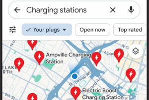
With the updated Maps, EV drivers using Android and iOS devices will be informed of charging station information, including the chargers’ compatibility with their vehicles and the speed at which the station charges. These updates have begun rolling out globally on iOS and Android in locations where EV charging station information is available, Google said.
Drivers of any kind of vehicle, or those who drive cars with Google Built-in, the company’s own operating system integrated in cars’ infotainment system sold in select markets, will also benefit from more detailed surroundings depicted by Maps.
In addition to updated colors throughout the map, the tool will now display a more realistic animation of a building one is driving toward, and bridges or exits on the highway and their lane markings.
The above updates started rolling out in 12 countries, including the US, Canada, France and Germany; in Europe, Google Maps’ AI-powered speed limit information has expanded to 20 countries.
Google Maps’ new Immersive View feature presents an aerial and street view of a place for those who are driving, cycling, or walking.
“You can prepare for each turn as if you were there with detailed, visual turn-by-turn directions, and use the time slider to plan when to head out based on helpful information, like simulated traffic and weather conditions,” the company explained.
Immersive View for routes started rolling out in Amsterdam, Barcelona, Dublin, Florence, Las Vegas, London, Los Angeles, Miami, New York, Paris, San Francisco, San Jose, Seattle, Tokyo, and Venice on Android and iOS, the company added.
Google claimed that its Lens in Maps (formerly known as Search with Live View) will let users utilize AR and AI to explore new communities. The functionality will soon be available in over 50 more cities, such as Taipei, Austin, Las Vegas, Rome, São Paulo, and Las Vegas.
For some searches, Google Maps will also offer information topically arranged to assist users in “finding inspiration and discovering new places.” Developers may now design their own immersive experiences with the introduction of Photorealistic 3D Tiles in Google Maps Platform a few weeks ago.